Titel
‘Map of the Menai Strait at and adjacent to the Suspension Bridge’, 1828.
Caption
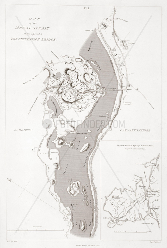
Map showing the suspension bridge over the Menai Strait between Carnarvon on the right (now Gwynedd) and the Isle of Anglesey (left). The bridge connecting the Welsh mainland with Anglesey was designed by Thomas Telford (1757-1834) and was built between 1818 and 1826, replacing the ferry. It opened on 30 January 1826. Also shown is a map of the island of Anglesey indicating the New Mail Road from Holyhead to London which carried the post between London and Ireland. Illustration from ‘An historical and descriptive account of the suspension bridge constructed over the Menai Strait ”¦’ by W A Provis (1792-1870), published in 1828., 6964544
Aufnahmedatum
01.01.2009
Bildnachweis
Science & Society / FOTOFINDER.COM
Bildname
10437768
Bildgröße
2364px x 3508px, 20,00 cm x 29,70 cm (300 dpi)
Model Release
Kein Model Release vorhanden
Property Release
Nicht spezifiziert
Mehr Infos Weniger Infos
Ort
Gwynedd
Land
United Kingdom
Bildanbieter
© Science & Society / FOTOFINDER.COM - Veroeffentlichung nur gegen Honorar, Urhebervermerk und Belegexemplar an FOTOFINDER.COM @ Ali Paczensky e.K., Buelowstr. 27, 10783 Berlin. Hinweis: NO MODEL-RELEASE! Bei werblicher Nutzung vorher Kontakt aufnehmen via E-Mail: info@fotofinder.com, Telefon: +49 (0)30 9150 0486. Ueberweisung des Honorars erfolgt an: FOTOFINDER.COM e.K., Deutsche Bank IBAN: DE64 1007 0024 0461 7700 00, BIC: DEUTDEDBBER.
Fotofinder.com Bildnummer
6964544
/ EAF3633833CFA8BC
Stichworte Stichworte
19. jahrhundert
, Anglesey
, Carnarvon
, Menai
, abbilden
, aufzeichnen
, bangor
, bauingenieurwesen
, beurlaubung
, branche
, bruecke
, bruecken
, einpassen
, enge
, faehre
, formatierung
, funktion
, gewerbe
, handel
, handwerk
, industrie
, industrielle revolution (1780-1869)
, ingenieurbau
, insel
, karte
, landkarte
, meerenge
, nachrichtentechnik
, nachrichtenweitverkehr
, natuerliche umgebung
, natur
, ow_science-society
, pmscartandhistory
, pmscinternational
, postal
, striemen
, sund
, suspendierung
, technologie
, telekommunikation
, tiefbau
, ueberholen
, vorhalt
, wales
, warten
, wissenschaft
Nutzung anfragen
Beratung per Telefon:
+49 30 9150 0486
Montag - Freitag 09:00 bis 18:00 (MEZ)
Montag - Freitag 09:00 bis 18:00 (MEZ)