Titel
'Physical map of the World’, 1849.
Caption
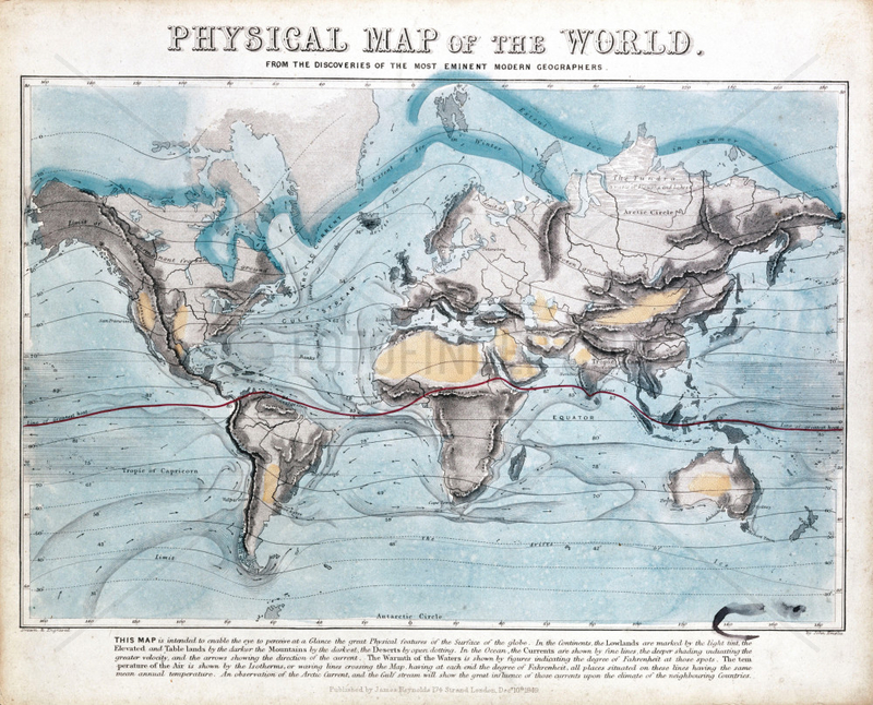
One of a set of teaching cards published by James Reynolds & Sons, London, England in 1849. Titled 'Physical Map of the World', the chart was drawn and engraved by John Emslie. It shows the distribution of mountain ranges, deserts and the seasonal range of the Earth's icecaps. In addition global ocean currents are shown along with air and sea temperatures around the world., 7023568
Aufnahmedatum
01.01.2009
Bildnachweis
Science & Society / FOTOFINDER.COM
Bildname
10325820
Bildgröße
3504px x 2827px, 29,70 cm x 23,90 cm (300 dpi)
Model Release
No Model Release available
Property Release
Not specified
Mehr Infos Weniger Infos
Land
United Kingdom
Bildanbieter
© Science & Society / FOTOFINDER.COM - Each publication includes royalties, copyright notice and voucher copy, please send to Fotofinder GmbH i.L. , Buelowstr. 27, 10873 Berlin, Germany. NO MODEL-RELEASE! For commercial usage please contact us: fulfillment@fotofinder.com, phone: +49 (0)30 25 79 28 90 or fax +49 (0)30 25 79 28 999. Payment to: Fotofinder GmbH, Deutsche Bank, IBAN: DE03 1007 0024 0041 4862 00, BIC: DEUTDEDBBER.
Fotofinder.com Bildnummer
7023568
/ 667F0455F7DF59BB
Stichworte Stichworte
Arctic pack ice
, Earth
, Industrial Revolution (1780-1869)
, James Reynolds & Sons
, NATURAL WORLD
, Planets
, Solar System
, Victorian
, continents
, deserts
, geography
, maps
, mountain ranges
, ocean currents
, oceans
, ow_science-society
, physical geography
, pmscartandhistory
, pmscinternational
, temperatures
, world maps
Nutzung anfragen
Beratung per Telefon:
+49 30 9150 0486
Montag - Freitag 09:00 bis 18:00 (MEZ)
Montag - Freitag 09:00 bis 18:00 (MEZ)