Titel
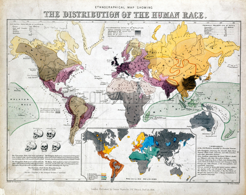
'Ethnographical Map Showing the Distribution of the Human Race’, 1851.
Caption
One of a set of teaching cards published by James Reynolds & Sons, London, England around 1851. Titled 'The Distribution of the Human Race', the chart was drawn and engraved by John Emslie. The map shows the population density around the world along with the ethnographic racial groups then recognised. The basis of these divisions is illustrated in a separate diagram showing the skull forms of different races. A smaller inset map also outlines the global distribution of the world's various religions., 7006882
Aufnahmedatum
01.01.2009
Bildnachweis
Science & Society / FOTOFINDER.COM
Bildname
10325817
Bildgröße
3504px x 2780px, 29,70 cm x 23,50 cm (300 dpi)
Model Release
No Model Release available
Property Release
Not specified
Mehr Infos Weniger Infos
Land
United Kingdom
Bildanbieter
© Science & Society / FOTOFINDER.COM - Each publication includes royalties, copyright notice and voucher copy, please send to Fotofinder GmbH i.L. , Buelowstr. 27, 10873 Berlin, Germany. NO MODEL-RELEASE! For commercial usage please contact us: fulfillment@fotofinder.com, phone: +49 (0)30 25 79 28 90 or fax +49 (0)30 25 79 28 999. Payment to: Fotofinder GmbH, Deutsche Bank, IBAN: DE03 1007 0024 0041 4862 00, BIC: DEUTDEDBBER.
Fotofinder.com Bildnummer
7006882
/ 2F9063EFB724FD41
Stichworte Stichworte
Earth
, Industrial Revolution (1780-1869)
, James Reynolds & Sons
, NATURAL WORLD
, Planets
, Solar System
, Victorian
, continents
, distribution
, ethnography
, geography
, human geography
, maps
, ow_science-society
, pmscartandhistory
, pmscinternational
, population
, population density
, race
, religion
, world maps
Nutzung anfragen
Beratung per Telefon:
+49 30 9150 0486
Montag - Freitag 09:00 bis 18:00 (MEZ)
Montag - Freitag 09:00 bis 18:00 (MEZ)